GIS 3015 Map Catalog

Tuesday, September 7, 2010

Cartogram

Cartogram - The normal space of a map is distorted to display collected data about a geographical area.

http://www.longwood.edu/staff/hardinds/Politics/Smoke-free_Virginia/SmokeFree2009.htm
http://www.longwood.edu/staff/hardinds/Politics/Smoke-free_Virginia/Majority%20Non-Smoking%202009%20cartogram_jpg.jpg
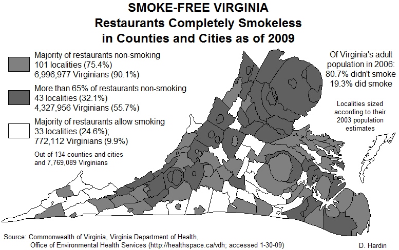
The above is a cartogram of smoke free restaurants by county in Virginia.
Posted by GIS 3015 Map Catalog at 10:44 AM
Email ThisBlogThis!Share to XShare to FacebookShare to Pinterest

No comments:

Post a Comment

Newer Post Older Post Home
Subscribe to: Post Comments (Atom)

Blog Archive

  • ▼  2010 (53)
    • ►  November (26)
    • ▼  September (27)
      • Topographic Map
      • Cartographic Animation
      • Mental Map
      • Statistical Map
      • PLSS Map
      • Thematic Map
      • Planimetric Map
      • Propaganda Map
      • Cadastral Map
      • DLG (Digital Line Graph)
      • DRG (Digital Raster Graphics)
      • Isopleths
      • Isopach
      • Isohyets
      • Isotachs
      • Isobars
      • LIDAR
      • Doppler Radar
      • Black and White Aerial Photo
      • Infrared Aerial Photo
      • Isoline Map
      • Flow Map
      • Proportional Circle Map
      • Cartogram
      • Choropleth Map
      • Dot Distribution Map
      • Hypsometric Map
Simple theme. Powered by Blogger.